David Evans alights at Charing Cross rail station and finds a connection to a medieval monastery in Clerkenwell
If you find the title of this piece confusing, let me take you to one of the busiest railway stations in the City of Westminster, Charing Cross, where a connection with Clerkenwell, just north of the City of London, might very well be the last thing on your mind as you board a train to a south-east London suburb or Kent.

Yet, at the close of the 15th century, much of the property of the then Hungerford Lane – also known as Brewer’s Lane – meandering down to the river Thames from the Strand was owned by the Priory of St John in Clerkenwell, the English headquarters of the Knights Hospitaller.
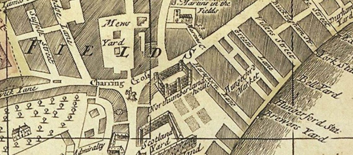
Today’s Hungerford Lane runs under the station’s elevated tracks and leads to the Embankment or Northumberland Avenue, but, even as late as the 1740s, John Rocque’s map of London shows Brewer’s Lane much as it might have been in the late 1400s, not far from the village of Charing and nearby bustling Westminster.
There, well before the establishment of Hungerford Market, the brewhouse was leased to a John Evingar, by the Prior of Clerkenwell, who held 11 cottages in the Lane altogether. Did he supply beer to the many alehouses in Westminster or even the houses of ill repute in the area? For, as early as the mid-1300s, travellers were commenting on the large number of these at Charing. Elsewhere, in Westminster proper, the Priory held one messuage (dwelling), one garden and several acres of arable land in the parish of St Margaret.
To the north of Hungerford/Brewer’s Lane lay the kitchen garden or Convent/Covent Garden supplying the Conventor Abbey of St Peter, Westminster, with produce. In 1516, John Islip, Abbot and Prior of Westminster, leased ‘all of their garden at Charing Cross called Covent Garden together with seven acres of land outside the close of the said garden to the north, for 41 years at an annual rent of 106s 8d’ to Thomas Docwra, Prior of the Hospitallers in Clerkenwell.
In addition, the Clerkenwell Priory was each year, on the Feast of St James, required to pay an additional rent of one bushel of apples and one of pears, which were to be laid on the high altar of the Abbey for blessing. A bushel is equal to eight gallons in capacity, so the altar must have looked like a market stall if the fruit was not in containers.
Because both priors were members of the King’s Council, the question might be asked whether this deal was clinched before or after weighty matters of state were discussed? Of course, the religious changes of the 1530s, when Henry VIII split from Rome and the Priory’s lands and wealth were seized by the Crown, put an end to this arrangement of rental income from Hungerford/Brewer’s Lane and the income from the properties in Westminster.
- Museum of the Order of St John in Clerkenwell
- Islington Guided Walks, the website of the Clerkenwell and Islington Guides’ Association
Photo: section of 1724 map of London showing Charing Cross, St Martin’s Church and Hungerford Market, with Brewer’s Yard visible bottom right (from: A new and exact plan of the city of London and suburbs thereof; Henry Overton, 1724. Bern University Library)

